

 10
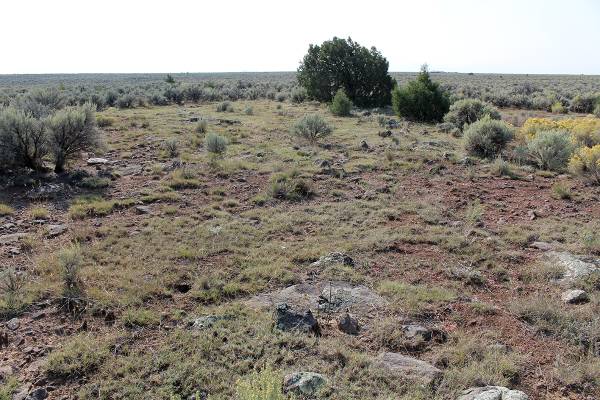
10Land for Sale - Tres Piedras Estates, Unit 4, about 35 minutes west of Taos Sale benefits public radio KCEI 90.1 FM 2 about Half Acre Lots in Unit 4 near the Petaca. Lot C is 130.5 ft. x 170.13 ft (.51 acres) and Lot J is 130.5 ft. x 165. 13 ft. (.49 acres) 3 miles Southwest of Tres Piedras, about 1.5 miles off of Hwy. 64 About 30 miles from Taos, near the San Juan Mountains west of Tres Piedras. The Western side of this unit is bordered by the beautiful Petaca Canyon. The Northern boundary features an unusual crater filled with a pasture. These are about half acre lots, twice as large as the lots in Two and Three Peaks. No water, No electric. Cell service available but no phone land lines. Dirt roads, sage, chamisa, wildflowers and native grasslands. Some piñon and juniper trees. Unit 4 Block 11 Lot J $6,500 and Unit 4 Block 11 Lot C $3,750 $1,750 discount for purchase of both lots. Both for $8,500 Purchase of both lots at $8,500, includes a quit claim for 6 adjoining lots listed as being "owned" by the Great Southwestern Land Company that has been long ago terminated by New Mexico Secretary of State Lots C for sale alone ONLY after Lot J sells These are separated by just one Lot, located on the North Western edge of Unit 4, by the Petaca canyon 300 - 500 Feet from the Petaca, Lot J half cleared a 10 years ago, with gramma grass and piñon and cedar trees. Some sage has begun to return, but can be pulled up again to keep the grass and wildflowers spreading. First photo is gramma grass meadow and trees fall 2018 Lot J 2nd and 3rd photo are gramma grass meadow and trees Lot J July 2025 4th photo is of grass and trees fall 2024 on Unit 4 Block 11 Lot J 5th Photo is the Petaca canyon near Unit 4 Block 11 Lot J and Block 11 Lot C First Map shows relation of Unit 4 to Hwy 64 2nd map is a google map image of Unit 4 showing roads in the unit 3rd map is detail of Unit 4 Block 11 Lot J and Block 11 Lot C 4th and 5th maps are closer detail with apx GPS points Water shown in Petaca is early spring, water recedes below sand in the summer 3rd to 5th maps are only approximate, must be confirmed from known survey stakes from original survey. The 5th map shows the GPS corners, +/- 6 ft, which are available, based on found survey stake NE corner Lot J 105.9423393, NW corner Lot C, 36.6098074, -105.9417597, NE corner Lot C, 36.60944896, -105.94176, SE corner Lot C, 36.60944844, -105.9423397, SW Corner Lot C, 36.60909, -105.94234, NE Corner Lot J, 36.60873156, -105.9423397, SE Corner Lot J, 36.60873206, -105.9429022, SW Corner Lot J, 36.6090905, -105.9429026, NW Corner Lot J, 36.60909, -105.94234, NE Corner Lot J
